


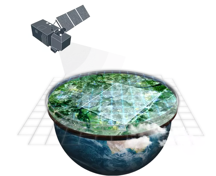
The ocean, which makes up more than 70% of our planet, plays a crucial role in providing oxygen, food, and employment. Unfortunately, it faces serious threats from pollution, overfishing, and climate change. To effectively safeguard this vital resource, early monitoring is essential. Thanks to high-res imagery from satellite sensors and cutting-edge geospatial methods, scientists can now keep a close eye on the ocean, yielding important insights.
However, gathering precise data from the deeper, open ocean remains a challenge due to the sparse buoy networks. Fortunately, advancements in marine sensors enable researchers to explore these remote regions, enhancing our understanding of ocean health, forecasting weather patterns, and preserving ecosystems.
Satellite Technology for Ocean Observation
The opportunity to get high-resolution satellite imagery in near real-time is essential for keeping an eye on the health of our oceans, delivering crucial information about ocean acidification, pollution, and climate change. It helps us monitor important elements like CO2 concentrations, sea surface temperatures, and salinity, which helps researchers grasp the impacts of plastic waste, algae blooms, and rising temperatures on marine life.
David Applegate, USGS Director, said: “As the impacts of the climate crisis intensify… satellites are crucial to providing data and imagery to help make science-based decisions on key issues including water use, wildfire impacts, coral reef degradation, glacier and ice-shelf retreat, and tropical deforestation.”
With satellite remote sensing and high-resolution Earth images, we can track plastic debris, sea ice, and ocean currents in real time, providing a detailed perspective of the oceans that traditional ship-based methods can’t match. The integration of these technologies, along with underwater drones and artificial intelligence, is vital for safeguarding marine biodiversity and guiding global conservation initiatives.
Ocean Monitoring: Key Uses of Satellite Data
Christopher Crawford, USGS Landsat Project Scientist and Data Acquisition Lead noted: “We’re taking darkness out of the equation. Extending the ability to observe ice and polar ocean changes increases the probability of capturing major glacier calving events, wind-driven surface melting or warming, and coastal ocean ice shelf breakup that can be expected to occur more frequently in the future if the pace of warming does not slow.”
Let’s explore the important ways in which satellite data provides us with valuable insights and helps protect our marine ecosystems:
1. Sea Surface Temperature (SST) Monitoring
Satellites track global sea surface temperatures, helping scientists understand climate change effects, such as warming oceans. SST data is crucial for predicting weather patterns, hurricanes, and heat waves.
2. Ocean Color Monitoring
By analyzing the color of the ocean from high-res imagery, satellites detect phytoplankton concentrations, monitor algae blooms, and assess water quality. This data is essential for tracking marine ecosystems’ health.
3. Sea Level and Surface Height
Using radar altimetry, satellites measure sea level changes, providing critical data on rising sea levels, coastal erosion, and ice melting rates, which are essential for climate studies.
4. Ocean Circulation Patterns
Satellites monitor ocean currents, which are essential for understanding heat distribution across the globe. This information supports climate models, fisheries management, and maritime navigation.
5. Pollution and Debris Tracking
Remote sensing helps identify concentrations of marine pollutants, including plastic debris. Hi-def satellite images can pinpoint areas of pollution, aiding clean-up efforts and policy planning.
6. Sea Ice Monitoring
Satellites track the extent and thickness of sea ice, providing vital data for understanding polar climate changes and their global implications.
7. Salinity and Water Quality
Ocean salinity is monitored via satellites to assess ocean health and freshwater inputs, influencing ocean circulation and marine life conditions.
Apart from the listed parameters, there is another big issue that needs our attention — illegal fishing. Let’s zoom in on it to stress the importance of this problem and the necessity to monitor its extent.
Monitoring Fishing Activities with Satellite Data
A recent study by Global Fishing Watch (an independent fishing monitoring NGO) reveals that over 75% of the world’s industrial fishing vessels are not publicly tracked, highlighting significant gaps in ocean governance and the need for enhanced monitoring using satellite data and artificial intelligence.
“We can’t manage what we can’t see. In this data void, it is all too easy to do harm to the environment, mismanage marine resources, or disregard the law — and get away with it,” said Fernando Paolo, senior machine learning engineer at GFW.
Satellites have become the principal solution for overseeing fishing activities in our oceans, offering vital information that supports sustainable practices and helps to eliminate illegal fishing. Through advanced Earth observation technology, satellites can monitor the positions and movements of fishing boats, enabling authorities to ensure adherence to fishing laws and the protection of marine reserves.
A significant use of this technology is in addressing illegal, unreported, and unregulated (IUU) fishing. Satellites equipped with radar and optical sensors, which deliver ultra-high resolution satellite imagery, can identify suspicious activities in real time, even in the most isolated ocean areas.
This capability allows enforcement agencies to pinpoint and respond to vessels involved in unlawful fishing, such as operating in prohibited zones or surpassing catch limits. Such monitoring is essential for preventing overfishing, which poses a serious risk to marine ecosystems and the sustainability of fish populations.
In addition, AI-enhanced satellite systems play a crucial role in managing overfishing by offering valuable insights into fish migration and oceanic conditions, including temperature and currents. This information aids governments and fisheries in managing fish populations more effectively and ensuring that fishing practices remain sustainable.
Satellites deliver near real-time high-resolution satellite images to improve the precision of vessel tracking, providing a clear global perspective on fishing activities. These technologies equip decision-makers with the necessary data to regulate fishing practices and protect ocean ecosystems, establishing satellite monitoring as a vital component of ocean conservation initiatives.

Author:
Peter Kogut
Petro Kogut has a PhD in Physics and Mathematics and is the author of multiple scientific publications. Among other topics, he has a specific focus on a satellite imagery processing and application in his academic research. Currently, Prof. Dr. Petro Kogut also works a science advisor.