We all know that 2022 was a wet year, and that all rivers lead to the sea. But to what extent do floodwaters from extreme rainfall events impact the ocean?
A recent study by the NSW Department of Climate Change, Energy, the Environment and Water (DCCEEW) used data collected by robot-like devices to see how the plumes of river water entering the ocean from the 2022 floodwaters impacted the ocean.

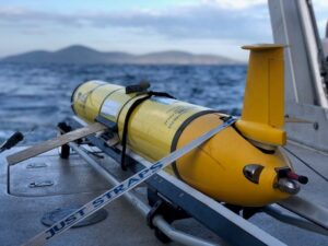
One of the autonomous ocean gliders used in the study to map the extent of the floodwaters from the 2022 floods.
Using salinity as a marker for extent of freshwater intrusion, the study found the influence of the 2022 floods into the ocean at river mouths was more significant than previously thought.
Tim Ingleton, a Marine scientist working on the project for DCCEEW, used data collected by robot-like instruments for the study.
The underwater robots, called autonomous ocean gliders, dive for extended periods of time to collect data on temperatures, pressure, and salinity of water before returning to the surface.
His team took the dataset collected by ocean gliders over a period of 13 years and focused on the salinity data.
They compared the 2022 NSW flooding events to the usual patterns.
What they found was surprising.
Dr Ingleton said the impact of the 2022 floods was record breaking in terms of ocean salinity levels.
“The longest low salinity event since we started recording salinity in 2008 all occurred in 2022, lasting for up to 2 months,” he said.
“After the extreme rainfall period in 2022, the freshwater plume was five times bigger than expected, and affected the water column down to 50m, deeper than ever seen before,” Dr Ingleton said.
Dr Ingleton said it was important to study the impact of freshwater on oceans as low salinity events effect marine life.
“When it rains a lot the freshwater flows down rivers and into the ocean. This is called a ‘freshwater plume’, and they make part of the ocean less salty and more dirty for a brief period. This creates low salinity events.”
“Low salinity can significantly impact ocean life. Plant life is particularly vulnerable, and when that changes then the species of animal and fish that are used to normal sea water conditions can move out of the area. Those that remain behind can struggle to survive.”
“Our study focussed on the freshwater plumes caused by the relative fresh floodwater entering the ocean from rivers during floods,” he said.
The robots that provided the data for this project, autonomous ocean gliders, are used all around Australia. They are funded, deployed and the data is processed by the Integrated Marine Observing System (IMOS). You can find more information about them here.
The Mapping Coastal Outflows project is an NSW Marine Estate Management Strategy funded project conducted by the Department of Climate Change, Energy, the Environment and Water.
You can learn more about the project from the webpage or reading the previous news on the project Big data for better understanding ocean outflows (nsw.gov.au).
Watch this space to find out more about our future NSW glider missions.
The full citation of the article is Malan, N., Roughan, M., Hemming, M. et al. Quantifying coastal freshwater extremes during unprecedented rainfall using long timeseries multi-platform salinity observations. Nature Communications, vol. 15, no. 424 (2024).
You can find the article Quantifying coastal freshwater extremes during unprecedented rainfall using long timeseries multi-platform salinity observations here.


