


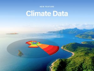
Global leader in marine weather forecasting, PredictWind, has unveiled a groundbreaking Climate Data feature – empowering users with access to month-by-month forecasts of wind, waves, and weather conditions anywhere on the globe, meaning they can be better prepared for their adventures at sea.
Insight from Ten Years of Historical ECMWF Weather Data
The Climate Data feature provides users with rolling averages of weather conditions from the last ten years, using observed historical weather data from the European Centre for Medium-Range Weather Forecasts (ECMWF).
Jon Bilger, PredictWind Founding Director commented: “This historical dataset is unique. We have used phenomenal amounts of computing power to collate and average the data for the entire world in 30 km resolution.”
This means users can confidently choose the optimal time of year for their next adventure by exploring:
- Wind (Windrose)
- Wave (Waverose)
- Air temperature
- Rainfall
- Wave height
- Sea surface temperature
- Cloud coverage
- Highest gusts
- Thunderstorm probability
- Visualise Weather Patterns Throughout the Year
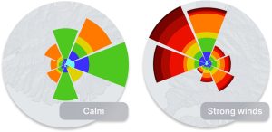
The Climate Data tool allows users to understand seasonal variability by displaying how wind, wave, and other weather patterns change across the four seasons.
“We’re proud to offer this historical data to PredictWind users, making it easier for them to identify the best months for calmer or more consistent conditions, and making it simpler to plan ahead for smoother sailing or to avoid potential extreme weather conditions,” said Bilger.
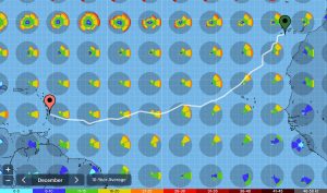
Extreme Weather: Plan Ahead With Confidence
Whether planning a voyage, leisurely sail or destination holiday, PredictWind Climate Data offers valuable insights into regions prone to extreme weather conditions like storms or high winds during certain months. This essential information allows mariners to steer clear of dangerous areas and choose safer routes.
Accurate and Reliable Data in the Face of Climate Change
Recognising the impact of climate change, PredictWind has eliminated possible inaccuracies by using only the most recent data from the past decade. Many traditional pilot charts rely on outdated weather information, however, Climate Data ensures accuracy by reflecting the current climate reality.
Vacation Planning: Choosing the Best Time for a Planned Activity
For those planning a kite foiling trip to Tahiti and wanting to know the best time to go for optimal wind conditions, Climate Data will show when the prevailing wind is best. Cross-referencing wind patterns with peak tourist seasons allows users to identify quieter months with great conditions. For example, insights revealing that the best winds for kite foiling occur just outside the traditional tourist season, allowing users to enjoy fewer crowds while still getting prime weather.
Over 154,000 Points of Interest with Local Knowledge
In addition to the powerful Climate Data feature, PredictWind’s Local Knowledge provides detailed information on over 31,650 global points of interest, including:
- 8,499 moorings and anchorages
- 11,326 marinas and harbours
- 3,233 boat ramps
- 1,552 navigational tips
- Plus many more locations, amenities, and activities
With Local Knowledge, users gain crucial on-the-ground information, ensuring they are fully prepared for their next adventure.
Better Prepare for the Next Adventure
From experienced mariners to those planning their first trip, PredictWind’s Climate Data and Local Knowledge features arms users with the power to plan their voyage with confidence. Access detailed, reliable information to navigate the seas safely and make the most of their time on the water. For more information, visit www.predictwind.com.