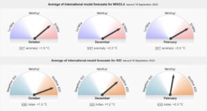
An El Niño and a positive IOD are underway.
The declaration of these events, and their concurrence over spring, reinforces the Bureau’s long-range rainfall and temperature forecasts, which continue to predict warmer and drier conditions for much of Australia over the next three months. The confirmation of an established El Niño increases the likelihood that the event will be sustained through the summer period.
Oceanic indicators firmly exhibit an El Niño state. Central and eastern Pacific sea surface temperatures (SSTs) continue to exceed El Niño thresholds. Models indicate further warming of the central to eastern Pacific is likely.

Broadscale pressure patterns over the tropical Pacific reflect El Niño, with the 90-day Southern Oscillation Index (SOI) at −7.7. Recent trade wind strength has been generally close to average, but was slightly weaker than average across the tropical Pacific in August 2023 for the first time since January 2020.
Overall, there are signs that the atmosphere is responding to the pattern of SSTs in the tropical Pacific and coupling of the ocean and atmosphere has started to occur. This coupling is a characteristic of an El Niño event and is what strengthens and sustains an event for an extended period. Climate models indicate this El Niño is likely to persist until at least the end of February. El Niño typically leads to reduced spring and early summer rainfall for eastern Australia, and warmer days for the southern two-thirds of the country.
A positive Indian Ocean Dipole is underway. The Indian Ocean Dipole (IOD) index is +1.25 °C for week ending 17 September. This is its fifth week above the positive IOD threshold (+0.40 °C). The longevity of this trend, combined with the strength of the dipole being observed and forecast, indicate a positive IOD event is underway. All models predict this positive IOD will persist to at least the end of spring. A positive IOD typically leads to reduced spring rainfall for central and south-east Australia.
When a positive IOD and El Niño occur together, their drying effect is typically stronger and more widespread across Australia.
The Madden–Julian Oscillation (MJO) is currently weak and is forecast to remain weak over the coming week.
The Southern Annular Mode (SAM) index is currently negative and is expected to remain negative for at least the coming week, before a possible return to neutral late in September. During spring, a negative SAM is associated with decreased rainfall across parts of the east in both NSW and Victoria, and increased rainfall over western Tasmania.
The long-range forecast for Australia indicates warmer and drier than average conditions are likely across most of southern and eastern Australia from October to December. The Bureau’s climate model takes into account all influences from the oceans and atmosphere when generating its long-range forecasts.
Global warming
Global warming continues to influence Australian and global climate. Global sea surface temperatures (SSTs) were warmest on record for their respective months during April to August 2023. August 2023 SSTs were also the warmest globally for any month since observational records began in 1850. July and August 2023 were also respectively the hottest and second-hottest months globally in terms of 2-metre air temperature.
Australia’s climate has warmed by an average of 1.48 ± 0.23 °C since national records began in 1910. There has also been a trend towards a greater proportion of rainfall from high intensity, short duration rainfall events, especially across northern Australia. Southern Australia has seen a reduction, by 10 to 20%, in cool season (April to October) rainfall in recent decades. This is due to a combination of natural variability on decadal timescales and changes in large-scale circulation caused by an increase in greenhouse gas emissions.
For more information visit www.bom.gov.au


