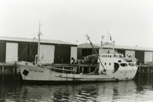
Early in the evening on Friday, 12 October 1973, the 44-metre coastal freighter MV Blythe Star cast its lines and departed Hobart bound for King Island. On board were 10 crew and a cargo of beer and fertiliser, the latter filling the ship’s hold and stacked atop its hatch covers.
In the days that followed, the ship and its crew disappeared without a trace.
This would trigger the largest maritime search ever conducted in Australia to that time. No trace of the MV Blythe Star or its crew would ever be found by the searchers. The search was called off after seven days.
The crew were assumed to have been lost with the ship.

MV Blythe Star. © Queen Victoria Museum via AUCHD
A tragedy unfolds at sea
Unbeknown to the rest of the world for nearly two weeks, the MV Blythe Star had listed (took on water and tilted to one side) and then suddenly sunk off the southwest coast of Tasmania. This was on the morning of Saturday, 13 October 1973. All 10 crew had been able to escape from the rapidly sinking vessel in an inflatable life raft.
Tragically, three crew died before the survivors were finally able to find help. Before then, they would be at the mercy of ocean currents. The crew drifted up and down the Tasmanian coast in the life raft, from South West Cape on the west coast up along Tasmania’s east coast, and then back south again.
They always had the shore in sight but were never able to find a safe place to land. Finally, they made their way ashore on a small beach at the bottom of steep cliffs on the rugged Forestier Peninsula. A couple of days later, on 24 October 1973, three of the survivors would climb the steep cliffs and struggle through dense bush to finally find help.
After they identified themselves as the crew from the Blythe Star, the first words from the first person they met were: “Nah, you’re all dead.”
In the end, they rescued themselves.
In the aftermath of the tragedy, there would be important changes made to maritime safety laws in Australia, improving safety at sea for future mariners.
How a ship lost for 50 years was found
The location of the wreck of the MV Blythe Star was confirmed by RV Investigator on 12 April 2023 during a research voyage off the west coast of Tasmania. The primary purpose of this voyage, led by the University of Tasmania, was to study a massive submarine (underwater) landslide on the continental shelf in the region.
The voyage included a ‘piggyback’ project to investigate an unidentified shipwreck in the region. This had been pinpointed by fishing vessels and previous seafloor surveys. Piggyback projects are in addition to the primary research project on a voyage. They use resources already allocated to a voyage to collect additional useful or important data for national benefit.
The investigation by RV Investigator, led by our project team, started by mapping the unidentified shipwreck using multibeam echosounders. This was followed by a visual inspection of the shipwreck using two underwater camera systems.

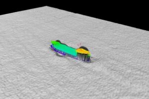
Bathymetric (seafloor) mapping showing port view of the wreck of MV Blythe Star. Image: CSIRO.
The seafloor mapping (called bathymetry) showed the unidentified shipwreck was lying in approximately 150 metres of water. The shipwreck is intact and sitting upright on the seafloor. Its bow is pointing towards the northwest, almost in the direction of King Island.
Importantly, the bathymetry showed that the shipwreck matched the dimensions and profile of the MV Blythe Star.
Confirming the identity of the Blythe Star
The mapping was used to plan the deployment of the underwater cameras from RV Investigator. The team onboard would carefully manoeuvre the cameras from the stern (back) to the bow (front) of the wreck, searching for key features to confirm its identity. They would compare the vision from below to the many historical photos of the MV Blythe Star that plastered the walls and desks in the Operations Room on RV Investigator.
It was a careful and deliberate process, with ocean currents, cloudy conditions and marine life all creating challenges for the camera operators. However, their investigation was successful.
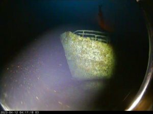
The visual inspection identified many distinctive features that confirmed the shipwreck was the MV Blythe Star. Most significantly, part of the vessel name, the word ‘STAR’, was identified on the ship’s bow.

An image from the underwater drop camera showing the word STAR on the bow of the shipwreck. © CSIRO
The bathymetry and visual inspection showed the vessel was intact and in relatively good condition. It was covered with minimal growth of algae and seaweed. Many marine creatures were now calling it home, with schools of fish, crayfish and several fur seals filmed by the underwater cameras.
It is hoped that the bathymetry and video imagery gathered may provide additional information to help answer questions about what caused the vessel to sink.
Closure
The MV Blythe Star was lost at sea less than a lifetime ago. Confirming its resting place holds an important meaning for many in the community.
The outcomes of this project have been shared directly with key stakeholders and partners. This includes the members of the recently formed Blythe Star Memorial Group. This group will hold an event in Hobart during October this year to commemorate the 50th anniversary of the tragedy.

CSIRO project team search for the ship name on the bow of the wreck. © CSIRO
The data and video footage from the project have been provided to state and national maritime heritage agencies as part of the reporting process for the Australasian Underwater Cultural Heritage Database. This database contains historical and environmental information about shipwrecks, sunken aircraft and other types of underwater heritage sites located in our region.
CSIRO are pleased to be able to assist in providing closure to this 50-year mystery and confirm the final resting place of the MV Blythe Star.
For more information visit www.csiro.au


